
May 2025 will be long remembered from a weather perspective for the extreme and record breaking temperatures that have been experienced in different regions and countries of the world. We have seen both maximum and minimum temperatures that are normally associated with the mid summer months and considerably above normal in South Africa, Central United States, the Middle East, Central Asia and yes, Iceland with some astonishing figures in the last few days.

On May 15, a new national May record was set at 26.6°C at Egilsstaðir Airport, Egilsstaðaflugvöllur in the east of the country, surpassing the 1992 record of 25.6°C in Vopnafjörður by a full degree. Three days later another extreme high of 26.4°C was recorded.
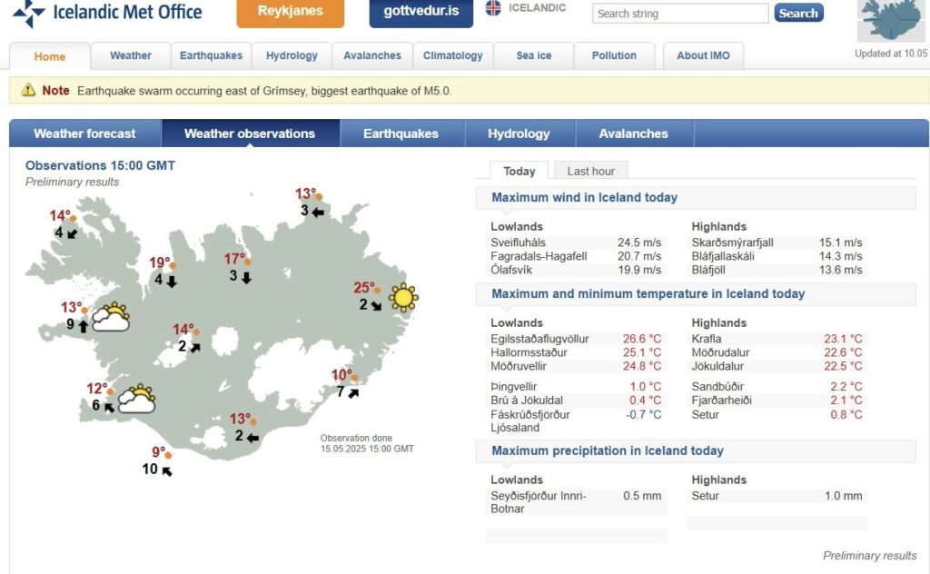
Other notable temperatures within this period included Stykkishólmur in the northern part of the Snæfellsnes peninsula, West Iceland, 175 km north of Reykjavik where 20.3°C was recorded, the highest May temperature since records began in 1885.
A record of 20.4°C was recorded on 18 May on Grímsey Island located off the coast of Northern Iceland and just north of the Arctic Circle – a remarkable temperature for such a high-latitude, subpolar location.
Iceland’s typical May temperatures range from 4–10°C in Reykjavík and slightly cooler in the north, with highs rarely exceeding 15°C . The 2025 heatwave produced temperatures 10–17°C above average, with highs of 20–26°C being unprecedented for spring.
Perhaps the most stunning and anomalous temperature to be recorded was that at a height of 950 metres at the Gagnheiði weather station located in the eastern highlands of the country. Sometimes also referenced as being the Fljótsdalshérað station. On the 15 or possibly 16 May a temperature of 20.3°C was recorded, shattering the previous monthly record of 12.9°C by an astonishing 7.4°C. At the time of writing while all the other records highlighted above have been ratified by the Icelandic Meteorological Office, this particular temperature is yet to be confirmed.
While not officially verified as Europe’s most extreme event, the anomaly is unmatched for Iceland’s climate and certainly is worthy of the descriptions that have followed the event.
The scale and enormity of this temperature anomaly can be seen in the context of previous data for this particular station as outlined below.
Annual Mean Temperatures:
- 2023: -1.7°C, the lowest annual mean in Iceland, reflecting its high-altitude, cold climate.
- 2022: -1.5°C, the lowest nationwide.
- 2021: -1.1°C, the lowest among all stations.
- 2024: -2.3°C, again the lowest,
Other records for the station include.
July 1995: Recorded a low average July temperature of 3°C, the lowest for that month until 2015.
July 2015: Set the lowest July average ever at an Icelandic station with 1.59°C, though the station’s records only began in 1993.
March 18, 2021: Gagnheiði recorded 9.9°C, breaking the previous March record of 9.4°C at 949m ASL, driven by warm air mixing near steep mountainsides.
February 5, 2025: During a severe storm, Gagnheiði recorded the strongest wind gust in Iceland at 66.3 m/s (238 kmph 148 mph), demonstrating its exposure to extreme weather.
Initial explanations of the cause of the higher than normal temperatures focus on a high-pressure system channeling warm southerly air, which was amplified by the Föhn effect, causing significant warming on leeward slopes in North and East Iceland.
The Föhn effect has caused significant high-temperature events worldwide including in Europe a monthly heat record a midnight temperature of 36.1°C in Oberndorf, Austria, on June 23, 2023. While in Sunndalsøra, Norway, a Föhn wind caused Scandinavia’s warmest winter temperature of 18.9°C on 28 January 2019.