Last year saw a unique and destructive hurricane season with a total of 18 named storms, 11 hurricanes and 5 major hurricanes. A number of records tumbled including Hurricane Beryl on 2 July, becoming the earliest ever Cat 5 hurricance by over two weeks.
Now with a week before the start of this year’s season there is a general consensus among the hurricane prediction community that this year will see a less intense season but still one with above average activity. The latest forecast published by NOAA’s National Weather Service in the last week predicts a range of 13 to 19 total named storms. Of those, 6-10 are forecast to become hurricanes, including 3-5 major hurricanes (category 3 and above. NOAA has a 70% confidence in these ranges.
The forecast uses analysis of the current status of factors that are key drivers in determining the severity of the season.
NOAA’s outlook for the 2025 Atlantic hurricane season, which runs from 1 June to 30 November predicts a 30% chance of a near-normal season, a 60% chance of an above-normal season, and a 10% chance of a below-normal season.
Predictions from a number of organizations are listed below:
| Organisation | Named Storms | Hurricanes | Major Hurricanes Cat 3+ |
| NOAA | 13-19 | 6-10 | 3-5 |
| Colorado State University | 17 | 9 | 4 |
| University of Arizona | 15 | 3 | 3 |
| N Carolina State University | 12-15 | 6-8 | 2-3 |
| AccuWeather | 13-18 | 7-10 | 3-6 |
| The Weather Company | 19 | 9 | 4 |
| Tropical Storm Risk | 15 | 3 | 3 |
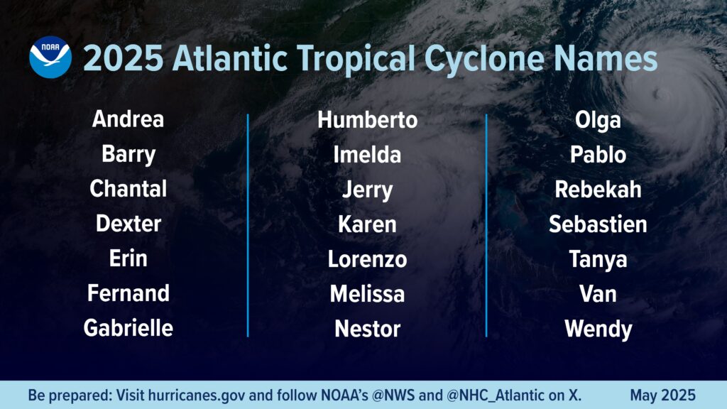
A total of 21 names in alphabetical order have been chosen by the World Meteorologial Organisation to be given to hurricanes occurring this season.
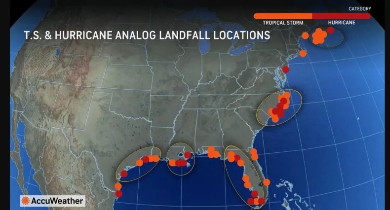
The Accuweather analysis published in late March predicts that Florida faces a 92% chance of a named storm and 65% chance of a hurricane passing within 50 miles, with the Gulf Coast (33%) at higher risk than the East Coast (26%). Texas, Louisiana, and the Carolinas are also flagged for elevated risks this year.
The analysis and further monitoring of three key factors are important in predicting the season ahead – sea surface temperatures, El Niño-Southern Oscillation (ENSO) phase and the development of African easterly waves
The Gulf and Caribbean temperatures remain warmer than average, fueling potential early-season storms, though the Main Development Region (MDR) in the eastern Atlantic is cooler than 2024, which could have a limiting impact on mid-season activity.
In terms of the ENSO Phase, a weakening La Niña is expected to transition to neutral conditions by summer, reducing wind shear and supporting storm formation, unlike El Niño’s suppressive effect.
African Easterly Waves (AEWs) are disturbances that are critical for hurricane formation, are often under-accounted for in models but could enhance activity if monsoon activity is strong. There can be the potential for a northward shift of the West African monsoon, producing tropical waves that seed some of the strongest and most long-lived Atlantic storms. The latest research suggests that African easterly waves contribute to the intensity, timing, and location of formation of hurricanes in the Atlantic but do not affect the number that might form in a given season.
NOAA has made a commitment to enhancing the forecast communications, decision support, and storm recovery efforts for the 2025 hurricane season with some specific improvements including an update in the analysis and forecast model which will improve tracking and intensity forecasts by an additional 5%. Also there is a focus on improving preparation time with advisories from the National Hurricane Center and Central Pacific Hurricane Center being produced 72 hours ahead of tropical storm force winds or a storm surge.
NOAA’s Climate Prediction Center is also planning to extend the Global Tropical Hazards Outlook from two weeks to three weeks, offering again earlier notice of potential tropical cyclone risks to enhance preparation and response.
The National Hurricane Center (NHC) will once again be using the experimental forecast cone graphic for 2025, showing inland tropical storm and hurricane watches and warnings for the continental U.S. This year, it will also highlight areas where a hurricane watch and tropical storm warning overlap.
We anticipate the forthcoming season in the midst of the implementation of significant cuts to the National Oceanic and Atmospheric Administration (NOAA) and its National Hurricane Center (NHC) as part of a broader effort to reduce federal spending and eliminate perceived bureaucratic inefficiencies by of The Department of Government Efficiency (DOGE). Initial layoffs accounted for about 6–7% of its 12,000–13,000 workforce with further planned cuts resulting in a total workforce reduction to nearly 20%.
The cuts in personnel are most likely to be seen operationally in terms of Hurricane Forecasting and in particular at The Environmental Modeling Center which will risk any potential gains in tracking and forecasting improvements. The Hurricane Hunters service also faces reduced capacity, potentially lowering forecast accuracy and affecting evacuations.
Staff shortages have seen reductions in weather balloon launches in Alaska, New York, and Maine, limiting hurricane modeling data. Automated translation of weather alerts into Spanish and other languages has also been suspended.
Speaking to the New York Times, Phil Klotzbach, a researcher at Colorado State University commented “The key for the forecast models is to keep all of the input data coming in. If we were to suffer from significant reduction in weather balloon launches or buoy data, for example, that could curtail forecast skill. But at this point, we don’t really know how much input data we would lose.”