


Storm Floris was notable as the strongest August storm since the Met Office began naming storms in 2015, with only eight summer storms recorded in June-August since then. Floris was classified as undergoing explosive cyclogenesis due to a significant drop in its central pressure.
Storm Floris, the sixth named storm of the 2024-2025 storm naming season, originated as a low-pressure system near the Great Lakes in the United States on Thursday 31 July . It underwent rapid intensification due to an active jet stream across the Atlantic, undergoing explosive cyclogenesis, often referred to as a “weather bomb,” where its central pressure dropped significantly by 24 millibars within a short period. A sharp temperature contrast between cold air over Canada and warmer air over the western Atlantic and eastern US fueled the jet stream’s strength.
By Saturday 2 August, the system had developed into a named storm in the west North Atlantic, covering approximately 2,500 miles (4,020km) before reaching the UK. The storm’s minimum central pressure was recorded at 983 mb on Monday 4 August at 06.00 as it approached western Scotland, providing an indication of potential strength although less intense than than Storm Éowyn at 941 mb. The Met Office issued a yellow wind warning on Friday 1 August which was subsequently upgraded to an amber warning for much of Scotland as increased confidence developed in relation to understanding the path and strength of the storm.
The storm made landfall early on Monday 4 August primarily affecting the northern half of the UK, with Scotland, Northern Ireland, northern England, and north Wales in its path. The storm’s centre was located just northwest of Orkney by Monday evening, with the strongest winds circulating close to this area. It brought heavy rain and strong winds across northern areas, moving eastward throughout the day. By late Monday, winds began to ease in western parts of the UK but remained strong in the east, particularly northeastern Scotland, until early Tuesday 5 August. The storm then moved northeast, affecting Orkney and Shetland into Tuesday morning before clearing the UK, leaving behind blustery conditions and showers in northern areas.
There were notably different winds speeds experienced realative to the altitude of the location. The highest wind speed experienced was a gust of 134 mph (215 km/h) on Ben Macdui in the Cairngorms, Britain’s second highest mountain at 1,237 meteres above sea level. A gust of 124 mph (200 km/h) was also recorded on the summit of Cairn Gorm which stands at 1,245 meters above sea level
The strongest low-level gust in Scotland, tying the August record for the region was seen at Wick on the north east coast of Scotland with a speed of 83 mph (134 km/h). On South Uist in the Outer Hebrides on the western side of the country a gust of 80 mph (129 km/h) was measured. In Norther Ireland, 66 mph (106 km/h) gust at Orlock Head (Point), County Down, tied the August record for Northern Ireland’s strongest wind gust.
Heavy rainfall of 20-30 mm widely and up to 40-60 mm in hilly areas of northwest Scotland caused some localized flooding, with flood warnings issued for the River Oykel and Churchill Barriers in the Orkney Islands. Fallen trees, exacerbated by full leaf cover, blocked drains and increased flooding risks.
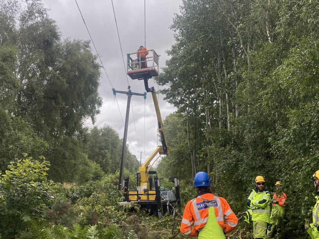
Over 43,000 homes in Scotland, particularly in the Highlands, Moray, and Aberdeenshire, lost power at the storm’s peak. Scottish and Southern Electricity Networks (SSEN) described Floris as “the most damaging summer storm in recent memory.” By Tuesday, August 5, 2025, SSEN had restored power to over 65,000 homes, but 6,300 remained without electricity, with some expected to be without power until Thursday, August 7, 2025.
In Northern Ireland, about 10,000 properties were initially affected, with 2,700 still without power by Monday evening. In the Republic of Ireland, Co Donegal and Co Roscommon saw significant outages, with 2,700 homes, farms, and businesses still affected by Monday afternoon.
Network Rail Scotland reported 119 incidents, including 75 tree-related issues, such as trees falling on overhead lines. By Tuesday, 31 of 34 routes had reopened, but disruptions continued due to debris clearance. Speed restrictions were still in place through the next couple of days.
Ferry services, including those between the Scottish mainland and the Western Isles, were cancelled, and routes in the Irish Sea aced delays or cancellations. Flights were cancelled at Belfast City and Dublin Airports, with Aer Lingus cancelling services to multiple UK destinations.
The Royal Edinburgh Military Tattoo cancelled its Monday show, and several Edinburgh Fringe Festival events, including Fringe by the Sea in North Berwick, were called off as a precaution.