
From 21-24 June, a powerful heat dome, a high-pressure system trapping hot air drove record-breaking temperatures across the central and eastern United States, with relentless heat building daily and offering little respite.
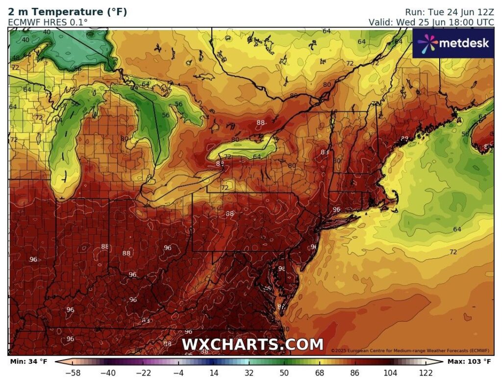
Described as “near historic” for its intensity, the heat wave was worsened by high humidity and limited overnight cooling, with lows ranging from the mid-70s to near 80°F (21–27°C). Daytime highs soared into the 90s and low 100s (32–40°C), pushing heat index figures as high as 115°F (46°C) in some areas. Temperatures in affected regions were up to 20°F (7°C) above average.
The Weather Service’s HeatRisk tool, which considers the duration, humidity and overnight temperatures, rates portions of the central and eastern United States at a Level 3 or 4 through at least to the end of the week, indicating a major to extreme risk of heat-related health impacts, especially for vulnerable groups. Level 4 being the highest category.
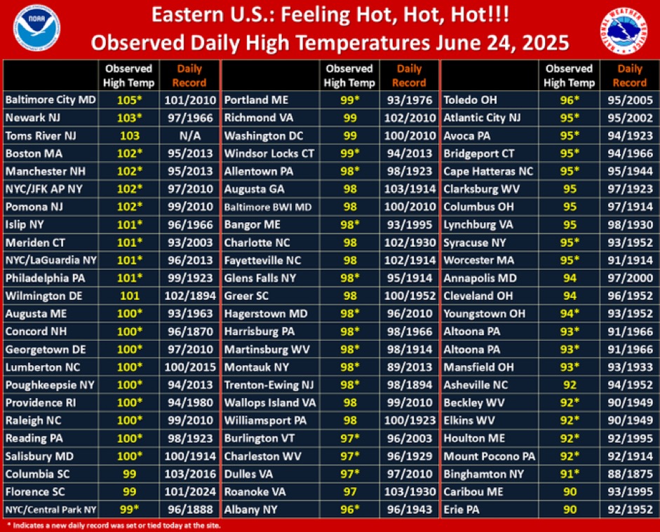
Notable and record breaking temperatures included downtown Baltimore reaching 104°F (40°C) on 23 June and a figure of 105°F (40.6°C) a day later beating the previous record for the date set in 2021. It was just shy of the region’s all time June high of 106°F (41.1°C).
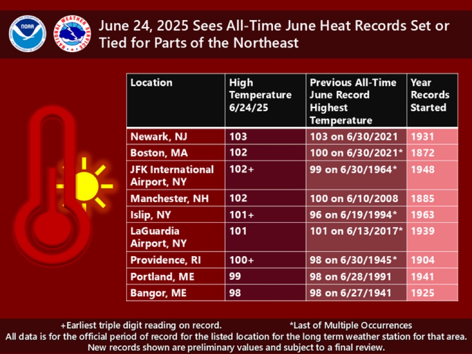
Newark, N.J., hit 101°F (38.3°C) on 23 June surpassing the previous record of 99°F (37.2°C) set last year and this was followed a day later with a temperature of 103°F (39.4°C).
New York City tied a longstanding daily record of 96°F (35.5°C) for the 23rd, set in 1888 in Central Park with also a temperature of 102°F (38.9°C) at JFK International Airport a day later.
Boston recorded a temperature of 102°F (38.9°C) and just two degrees below the highest temperature ever recorded in the city which stands at 104°F (40°C) set on 4 July 1911.
In Philadelphia, where a heat health emergency was declared by the city’s public health department, the temperature reached a record-breaking 99°F (37.2°C) on the 23rd. The last time 100°F (38.8°C) was reached in the city was in June 1994.
The National Weather Service (NWS) has issued heat advisories and excessive heat warnings for multiple states as roughly 245 million people experienced temperatures at or above 90°F (32°C) and about 33 million faced temperatures at or above 100°F (37.8°C).
The Climate Shift Index (CSI) a daily temperature attribution system developed by Climate Central applies the latest peer-reviewed methodology to map the influence of climate change on temperatures across the globe on a daily basis. This allows for rapid quantification of how climate change has influenced the intensity and likelihood of a particular extreme weather event and allows for rapid analysis.
Dr. Zachary Labe, Climate Scientist at Climate Central, comments:
“The extent of this early summer heat dome over the United States is remarkable. Thanks to scientific advances, we can now show a clear climate change fingerprint in real time using the Climate Shift Index. It is a stark reminder that climate change is making these dangerous and oppressive heat waves far more likely, affecting millions of people.”
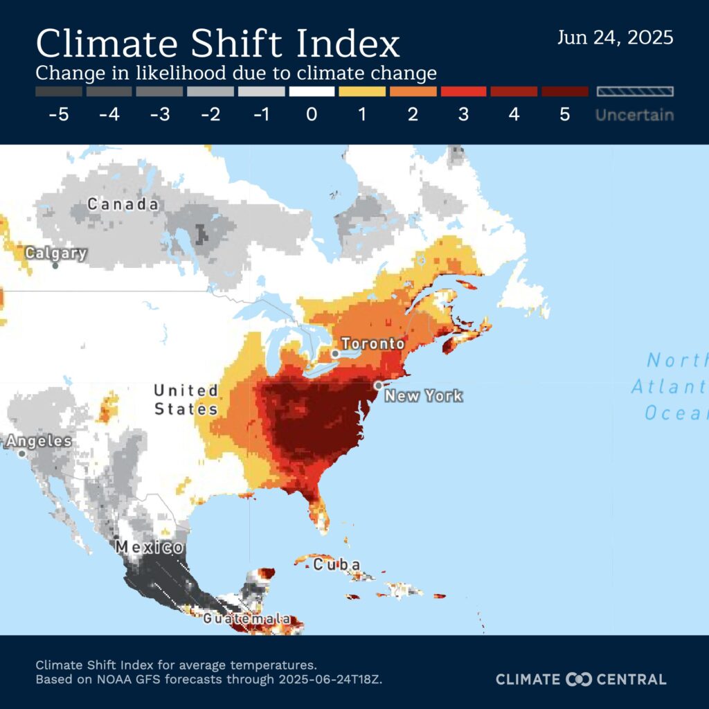
A CSI level 5 indicates that human-caused climate change made this excessive heat at least 5 times more likely,signifying an exceptional climate change event. Climate Central predict during the duration of the heat wave 69 million people in the United States. will experience at least one day with CSI level 5. The population size increases to 174 million experiencing at least one day with CSI level 3.
Elsewhere in the country, Salt Lake City, Utah, recorded its first triple-digit temperature of 2025 as it reached 104°F (40°C ) on 20 June, while Mitchell, South Dakota, also recorded 104°F (40°C ) on 22 June, surpassing the previous daily record of 101°F (38.3°C). Daily maximum temperature records were also broken in parts of Minnesota, Wyoming, and Michigan.